
Set the basemap in the Format pane
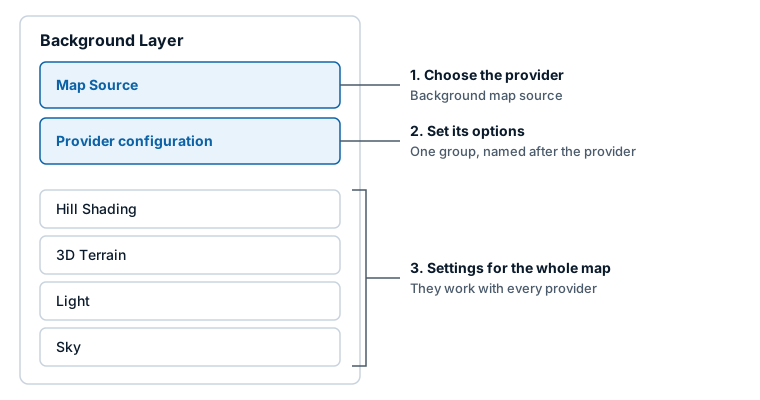
The Background Layer card in the Format pane chooses the map's basemap and sets its options. Pick a provider from one dropdown, then fill in the group that appears for it.
This page is for maps that predate the Basemaps dialog: maps built before 1.1.0.10 and later switched to the Modern engine, and maps built in Icon Map Lite and switched to Icon Map Pro. A map added as a new visual in 1.1.0.10 or later shows only a Basemaps group on this card and uses the Basemaps dialog instead. Basemaps overview explains the rule.
Change the basemap
- Select the map and open the Format pane.
- Expand Background Layer.
- In Map Source, choose a provider in Background map source.
- A configuration group for that provider appears below. Set its options. For Icon Map, choose a style in Icon Map Tiles - Configuration > Layer.
- If the provider needs a key, enter it under API Keys & Authentication. See API keys, authentication and the proxy.
The map redraws as you change each setting.
How the card is laid out
| Group | What it holds |
|---|---|
| Map Source | Background map source: None, Icon Map, ArcGIS, Azure Maps, Mappable, Ordnance Survey, Raster Tiles, Vector Tiles or WMS. Default: Icon Map |
| The provider's configuration group | One group, named after the provider. Nothing appears for None |
| Hill Shading, 3D Terrain, Light, Sky | Settings for the whole map. See Terrain, hillshade, sky and lighting |
Google Maps, Mapbox, MapTiler and single-image backgrounds are part of the Legacy engine. See the documentation for 1.1.0.9 and earlier. If a map saved with one of them is on the Modern engine, the map draws an empty background and tells you to choose another one. Your saved settings are not changed.
Icon Map
Group: Icon Map Tiles - Configuration. The styles themselves are described in Icon Map basemap styles.
| Setting | What it does | Default |
|---|---|---|
| Layer | The Icon Map style. The list is loaded when the visual starts and shows "Loading map styles..." until it arrives | Standard |
| Show basemap selector | Shows a button on the map that lets readers switch between the Icon Map styles | Off |
| Language | The language of place names: Report language, which follows the report when it is in German, Spanish, French or Portuguese and is English otherwise, or one of 41 languages. Available only for styles that support languages | Report language |
| Extrude Buildings | Draws buildings in 3D by their height when the map is tilted. Available only for styles with building heights. Shown on and locked for styles that always draw 3D buildings | Off |
| Remove Labels | Hides the style's labels | Off |
| Remove Transportation | Hides roads and rail | Off |
| Show Boundaries | Shows administrative boundaries | On |
| Show Buildings | Shows building footprints | On |
| Show POIs | Shows points of interest. Locked for styles that have none | On |
| Show Land Use & Land Cover | Shows parks, woodland and other land areas. Locked for styles that have none | On |
| Override Formatting | Lets you set the two colors below | Off |
| Water Color | The color of water. Shown when Override Formatting is on | White (#FFFFFF) |
| Background Color | The color of land. Shown when Override Formatting is on | Light gray (#CCCCCC) |
| Show Hillshading | Adds shaded relief to the Icon Map style | Off |
When Show Hillshading is on, these settings appear:
| Setting | What it does | Default |
|---|---|---|
| Source | The elevation data: Mapterhorn (worldwide) or Icon Map Catalog | Mapterhorn |
| Choose from catalog | Opens the Icon Map Catalog to pick an elevation model. Shown when Source is Icon Map Catalog. Selected DEM then shows the one you chose | |
| Hillshade Exaggeration | How strong the shading is, 0 to 10 | 5 |
| Shadow Color | The color of slopes facing away from the light | #473B24 |
| Highlight Color | The color of slopes facing the light | #FFFFFF |
| Accent Color | The color that emphasizes sharp relief | #CCCCCC |
Show Hillshading works only with Icon Map styles. The Hill Shading group lower on the card shades any basemap and has more options. See Terrain, hillshade, sky and lighting.
To draw place names above your data instead of below it, switch on Remove Labels here and add the Map Labels reference layer. See Map labels on top of your data.
The style selector for readers
With Show basemap selector on, the map shows a button (tooltip "Change Map Style") that opens a panel headed "Map Background" listing the Icon Map styles. The same switch is on the Controls card. It is available only when the map source is Icon Map.
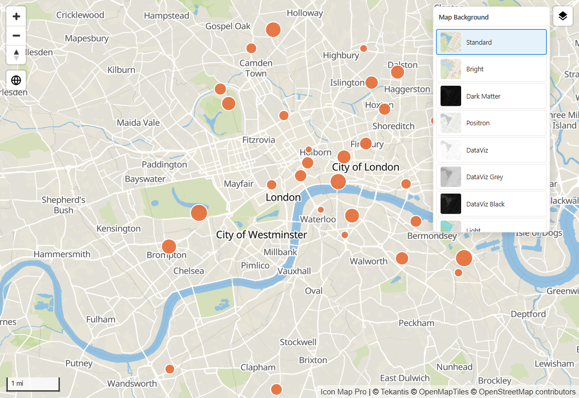
A reader's choice lasts for their session. While you are editing the report, choosing a style in the selector also saves it as the map's style.
ArcGIS
Group: ArcGIS - Configuration. Esri's basemap styles need a credential, set under API Keys & Authentication > ArcGIS Authentication: the ArcGIS and OpenStreetMap (via ArcGIS) types, and Custom Vector Style ID with an item ID. A public tiled service, a style given by its URL and a web map with public layers load without one. Until a credential is saved, the group shows a note pointing there. See Connect to ArcGIS.
| Setting | What it does | Default |
|---|---|---|
| ArcGIS Tiles Type | What kind of ArcGIS basemap to draw. The options are listed below | ArcGIS |
| ArcGIS Style | Shown for the ArcGIS type. Outdoor, Community, Navigation, Streets, Streets (relief), Imagery, Oceans, Topographic, Light Gray, Dark Gray, Human Geography, Charted Territory or Nova | Outdoor |
| OSM Style | Shown for the OpenStreetMap (via ArcGIS) type. Standard, Navigation, Streets or Blueprint | Standard |
| Language | Shown for the ArcGIS and OpenStreetMap (via ArcGIS) types. Global or one of 40 languages for place names | Global |
| ArcGIS Item ID | Shown for the Custom Vector Style ID type. The item ID of a vector basemap style in ArcGIS Online or Enterprise | Empty |
| ArcGIS Enterprise Basemap URL | Shown for the Tiled Basemap URL type. The address of a tiled map service | Empty |
ArcGIS Tiles Type options:
| Option | What it draws |
|---|---|
| ArcGIS | One of Esri's basemap styles |
| OpenStreetMap (via ArcGIS) | OpenStreetMap data styled by Esri |
| Custom Vector Style ID | A vector basemap style item of your own |
| Tiled Basemap URL | A tiled map service, for example from ArcGIS Enterprise |
New in 1.1.0.11 A fifth type, Web Map, draws the basemap layers of an ArcGIS web map.
| Setting | What it does | Default |
|---|---|---|
| Browse Web Maps | Opens Browse ArcGIS to search the web maps you have access to. The switch turns itself off again | Off |
| Web Map | The item ID or item page link of a web map. Only its basemap layers are drawn here. To draw its other layers too, add the web map as an ArcGIS reference layer. See ArcGIS layers | Empty |
A web map whose layers are public needs no ArcGIS credential.
A tiled service must use Web Mercator tiles. For a service in another spatial reference, the map shows a message naming it and draws no basemap.
Azure Maps
Group: Azure Maps - Configuration. Enter the key in API Keys & Authentication > API Keys > Azure Maps.
| Setting | What it does | Default |
|---|---|---|
| Style | Road, Dark Gray or Imagery | Road |
| Hill Shading | Adds Microsoft's shaded relief. Shown when Style is Road | Off |
| Labels | Shown when Style is Imagery. None, Roads, Boundaries and Labels, or Labels only | None |
| Language | The language of labels, from the Azure Maps list of 36 | English (USA) |
| Authentication Method | Azure Maps Key or Azure AD | Azure Maps Key |
| Azure AD Client ID | Shown when Authentication Method is Azure AD | Empty |
Mappable
Group: Mappable - Configuration. Enter the key in API Keys & Authentication > API Keys > Mappable.
| Setting | What it does | Default |
|---|---|---|
| Map type | Map or Driving | Map |
Ordnance Survey
Group: Ordnance Survey - Configuration. Enter the key in API Keys & Authentication > API Keys > Ordnance Survey.
| Setting | What it does | Default |
|---|---|---|
| Map Style | Road, Outdoor, Light or Vector Tiles | Road |
The tiles are drawn in Web Mercator. The raster styles (Road, Outdoor, Light) are available from zoom 7 to zoom 20.
Raster Tiles
Group: Raster Tiles - Configuration.
| Setting | What it does | Default |
|---|---|---|
| URL template for tile server | The tile template, for example https://tile.example.com/{z}/{x}/{y}.png. Supports conditional formatting (fx) |
Empty |
The tokens are described in Other basemap providers.
Vector Tiles
Group: Vector Tiles - Configuration.
| Setting | What it does | Default |
|---|---|---|
| URL of the style JSON file | A link to a MapLibre style document. Supports conditional formatting (fx) | Empty |
The link must be a style document, not a tile address. See Other basemap providers.
WMS
Group: WMS - Configuration.
| Setting | What it does | Default |
|---|---|---|
| WMS Server URL | The service address. It should start with https:// | Empty |
| Manual configuration | Lets you type the layer, CRS and format yourself instead of reading them from the service | Off |
| Layer | The layer to draw. A dropdown read from the service, or a text box when Manual configuration is on | Empty |
| CRS | Shown when Manual configuration is on. The Modern engine always requests the service in EPSG:3857 (Web Mercator) | EPSG:3857 |
| Format | The image format. A dropdown of the formats the service offers, or a text box when Manual configuration is on | image/png |
| Update Map Bounds | Reads the chosen layer's extent from the service, copies it to the four bounds under Map > Map Bounds and switches on Limit Map to Bounding Box. The switch turns itself off again. Shown when Manual configuration is off and a layer is chosen | Off |
Use Manual configuration when the layer list cannot be read from the service.
Tips and limits
- None draws no basemap and has no settings.
- Tile servers, style links and WMS services add no credit line of their own. Add the provider's credit in Format pane > Controls > Additional Attribution.
- On this card, conditional formatting (fx) is available on the tile template and the style link. See Conditional formatting.
- A WMS basemap is always requested in Web Mercator. If a different CRS was saved, the map says so and requests EPSG:3857.