
Labels on reference layers
A file reference layer can name its own features: the region on each polygon, the road along each line, the site at each point. The text comes from a property of the file, and each layer has its own label style.
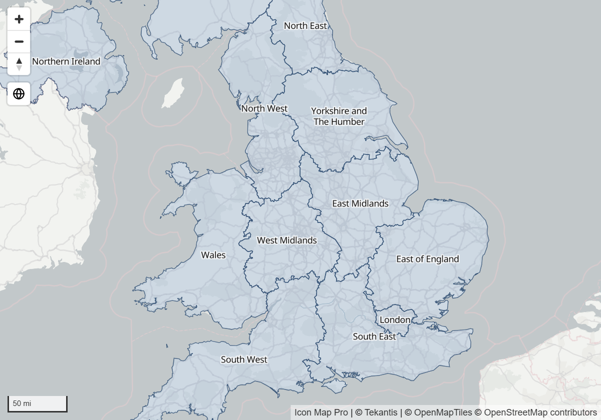
These labels belong to file layers. Labels for the rows of your data are set separately: see Data labels.
Turn labels on
In the Layer Manager, select the file layer and, under Labels and tooltips, switch on Show labels. Type the property that holds the text in Label property, then choose a Label style, Text size and Text color. Select Apply changes.
In the Format pane:
- Open Reference Layers and choose the layer in GeoJSON / KML / CSV / WFS - Setup > Apply settings to.
- In the layer's Configuration group, switch on Show Labels.
- Set Label Property Name to the property that holds the text. For an uploaded file it is a list of the file's properties. For a link, type the name.
- A GeoJSON / Shape / KML Layer {n} - Labels group appears below the layer's Formatting group. Style the labels there.
Label Property Name takes conditional formatting (fx), so a measure can switch the labels between two properties, for example a name and a code.
Label styles
Label Style sets the look of every label in the layer.
| Label Style | Looks like |
|---|---|
| Halo Text | Map text with a halo, an outline in a second color that keeps it readable over the map |
| Glass | A card that blurs the map behind it, with a tint you choose |
| Dark Glass | A dark card that blurs the map behind it |
| Card | A filled card with a border and a stripe in the accent color |
| Neon | A card with a glow in the accent color |
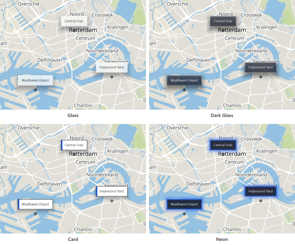
Halo Text is drawn as part of the map. The other four styles are cards, set in the font you choose.
Place the labels
Position
Position sets where a label sits relative to its feature: Center, Above, Below, Left or Right. On a polygon the label is placed inside the shape, so Center is usually the right choice. For the other positions, Distance sets how far the label sits from its feature, in multiples of the text size.
Pointers
A card can point at its location. Set Pointer to:
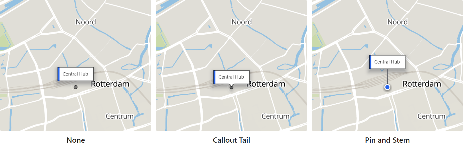
- None - the card sits at the position you choose.
- Callout Tail - the card sits to one side with a tail pointing back at the location. Position chooses the side.
- Pin and Stem - the card stands above the location on a line, with a pin at its foot. Stem Height (px) sets the length of the line.
Labels along lines
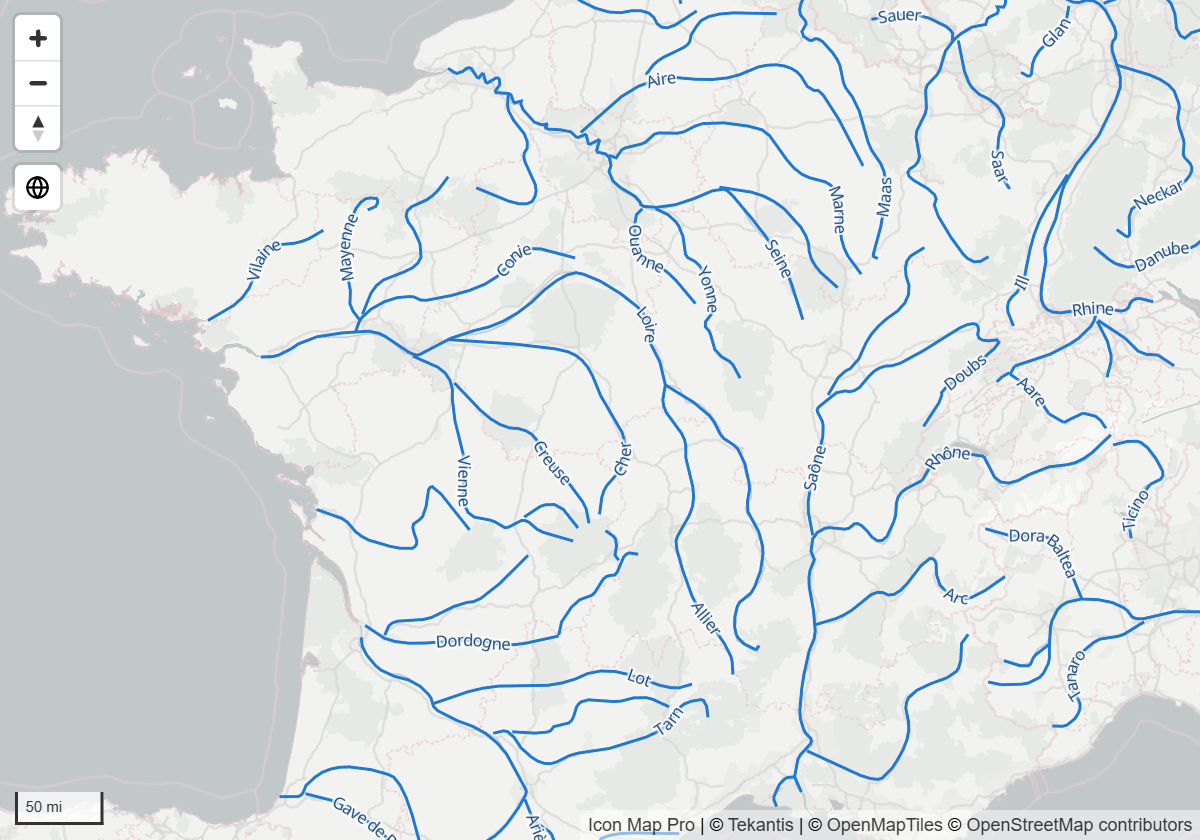
With Halo Text, switch on Labels Follow Lines to curve each label along its line and repeat it down the length of the line, the way a river or a road is named on a map. With it off, a line takes one upright label at its middle.
Labels Follow Lines works best on simple, smooth lines. On very detailed geometry, few labels may be placed.
Crowded maps
Hide Overlapping Labels is on by default: a label that would land on top of another is dropped. Switch it off to draw every label.
With Hide Overlapping Labels on, some labels are missing where they would collide, for example on neighboring regions when the map is zoomed out. Zoom in, or switch it off, to see them.
Maximum Width wraps long labels. It is measured in multiples of the text size.
Zoom range
Labels have a zoom range of their own, set with Min Zoom Level and Max Zoom Level. Use it to show labels only once the reader has zoomed in far enough to read them. Switch on Use Min/Max Zoom from Parent Layer to make the labels appear and disappear with the shapes they name instead.
Settings
Format pane > Reference Layers > GeoJSON / Shape / KML Layer {n} - Labels
The group is shown for the layer chosen in Apply settings to, when that layer's Show Labels is on.
| Setting | What it does | Shown for | Default |
|---|---|---|---|
| Label Style | Halo Text, Glass, Dark Glass, Card or Neon | All | Halo Text |
| Font Family | The font of the card | Card styles | Segoe UI |
| Text Size | Size of the text, 0 to 100 | All | 10 |
| Text Color | Color of the text | All | #000000 |
| Halo Color | Color of the outline around the text | Halo Text | #FFFFFF |
| Halo Width | Width of the outline, 0 to 20 | Halo Text | 1 |
| Accent Color | The stripe on a card, the glow of neon and the pin at the foot of a stem | Card, Neon | #2563EB |
| Background | Frosted blurs the map behind the label. Solid fill draws the fill as it is: fully solid at 0% transparency, or see-through without the blur above it | Glass, Dark Glass, Neon | Frosted |
| Frost (%) | How strongly the map behind the label is blurred. 0 turns the blur off | Glass, Dark Glass and Neon, with Frosted | 60 |
| Tint Color | The tint of the glass | Glass | #FFFFFF |
| Fill Color | The fill of the card | Card | #FFFFFF |
| Border Color | Color of the card's border | Card | #000000 |
| Border Width | Width of the card's border, 0 to 20 | Card | 1 |
| Border Radius | Roundness of the corners, 0 to 90. 0 gives square corners | Card styles | 0 |
| Transparency | 0 is solid, 100 is invisible | All | 0 |
| Pointer | None, Callout Tail or Pin and Stem | Card styles | None |
| Stem Height (px) | Length of the stem, 0 to 300 | Pin and Stem | 36 |
| Position | Where the label sits relative to its feature. With a callout tail, the side the card sits on | Pointer is None or Callout Tail | Center |
| Distance | How far the label sits from its feature, 0 to 10, in multiples of the text size | Pointer is None and Position is not Center | 1 |
| Maximum Width | Longer labels wrap. 1 to 60, in multiples of the text size | All | 10 |
| Hide Overlapping Labels | On: a label that would land on top of another is dropped. Off: every label is drawn | All | On |
| Labels Follow Lines | On: a label on a line curves along it and repeats. Off: a line takes one upright label at its middle | Halo Text | Off |
| Use Min/Max Zoom from Parent Layer | On: labels appear and disappear with the shapes they name | All | Off |
| Min Zoom Level, Max Zoom Level | The zoom range of the labels. Shown when Use Min/Max Zoom from Parent Layer is off | All | 0, 24 |
| Z-Index | Drawing order of the labels, 0 to 10000. Higher is nearer the viewer | All | 370 |
"Card styles" means Glass, Dark Glass, Card and Neon.
With Callout Tail, Position offers Above, Below, Left and Right. With Pin and Stem the card always stands above its location, so Position is hidden.
Tips and limits
- The labels follow the layer's filter. If Property to Filter and Filter Value hide a feature, its label is hidden too.
- Each layer's labels have their own Z-Index, separate from the layer's shapes. With the default of 370, the labels of one file layer are drawn above the shapes of the other file layers. Raise it above 405 to draw the labels over your circles as well.
- Labels work the same way for uploaded files, linked files and PMTiles archives.
- A report that styled its reference labels in an earlier version keeps its text size, colors, halo width, zoom range and Z-Index until you change them for a layer.
- The single Reference Labels group that is shared by all layers is part of the Legacy engine. See the documentation for 1.1.0.9 and earlier.
ArcGIS layers bring their labels from ArcGIS. Switch on Use ArcGIS Labels on the layer. See ArcGIS layers.