
ArcGIS layers
Draw the features of an ArcGIS feature layer as context for your data: boundaries, networks, sites. The layer is read from ArcGIS Online or ArcGIS Enterprise each time the report opens. You can have up to five ArcGIS reference layers.
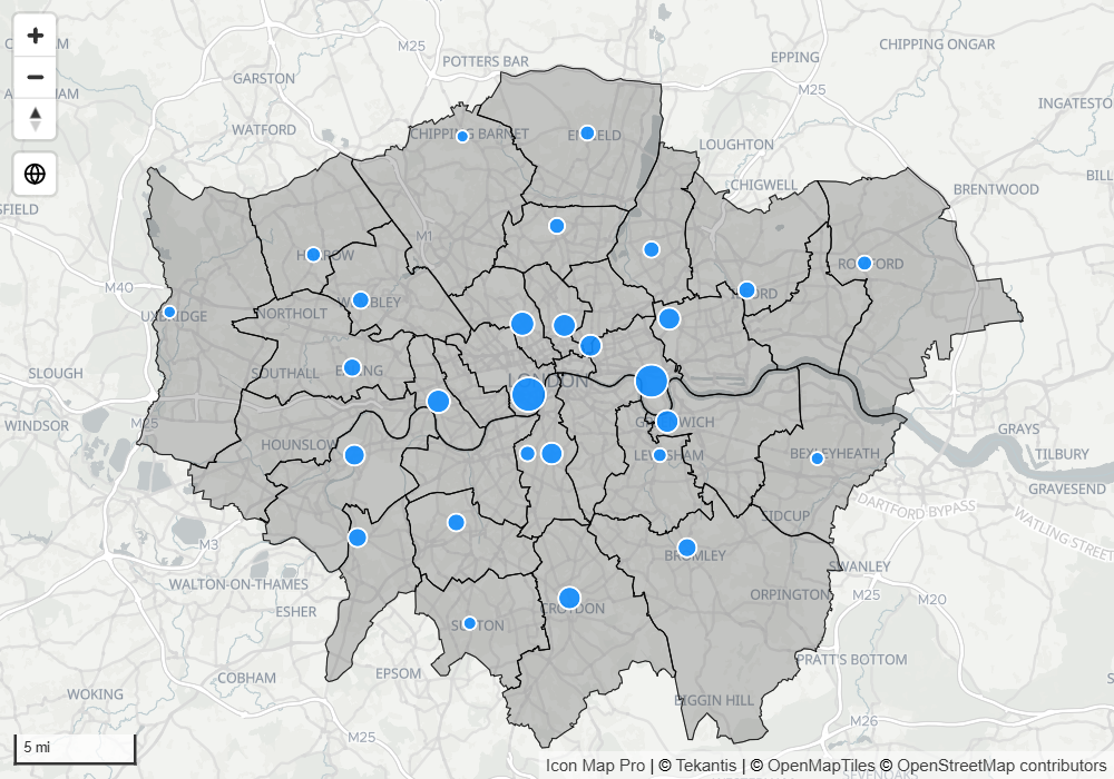
An ArcGIS reference layer is not joined to your data. To color ArcGIS features by a measure and cross-filter the report when they are clicked, see ArcGIS layers bound to data.
Before you start
- You need the address of a feature layer. It ends in
FeatureServerorMapServerfollowed by the number of the layer, for example.../FeatureServer/0. An address that ends inFeatureServerdraws layer 0. - Public layers need no setup. For private content, set up authentication first. See Connect to ArcGIS.
Add a feature layer
- In the Format pane, open Reference Layers > Layer Selection and switch on ArcGIS Feature Layer.
- In the layer's Configuration group, paste the address into ArcGIS Feature Layer URL.
- Set Fill Color, Outline Color and the transparency settings to suit your map.
To add another, increase Number of Layers in ArcGIS Feature Layer - Setup and choose the new layer in Apply settings to.
Show attributes as tooltips
Switch on Include Tooltips to show the attributes of a feature when the reader hovers over it. To show one attribute only, type its name in Tooltip Field. Tooltip Title replaces the attribute name with your own text.
Filter the layer by your data
SQL WHERE Clause sends a filter to ArcGIS so that only matching features are drawn, for example STATE = 'TX'. It takes conditional formatting (fx), so a measure can build the clause from the current slicer selection.
ArcGIS Feature Layer URL and Visible also take conditional formatting (fx), so a measure can choose the layer or hide it.
Settings
ArcGIS Feature Layer - Setup
Format pane > Reference Layers > ArcGIS Feature Layer - Setup
| Setting | What it does | Default |
|---|---|---|
| Number of Layers | How many ArcGIS reference layers the map has, 1 to 5 | 1 |
| Apply settings to | The layer whose settings the group below shows | Layer 1 |
Configuration
The group is named ArcGIS Feature Layer, the layer number and Configuration.
| Setting | What it does | Default |
|---|---|---|
| ArcGIS Feature Layer URL | The address of the feature layer. Takes conditional formatting (fx) | Empty |
| Visible | Shows or hides the layer. Takes conditional formatting (fx) | Yes |
| Outline Color | Color of outlines and lines | #000000 |
| Outline Transparency | 0 is solid, 100 is invisible | 20 |
| Outline Width | Width of outlines and lines, 0 to 100 | 1 |
| Outline Dash Array | Space-separated dash and gap lengths, for example 4 4. Empty draws a solid line |
Empty |
| Fill Color | Fill color of polygons | #555555 |
| Fill Transparency | 0 is solid, 100 is invisible | 70 |
| Include Tooltips | Shows a tooltip with the feature's attributes | Off |
| Tooltip Field | One attribute to show in the tooltip. Empty shows every attribute | Empty |
| Tooltip Title | Text to show in place of the attribute name | Empty |
| SQL WHERE Clause | A filter sent to ArcGIS. Takes conditional formatting (fx) | Empty |
| Include in Auto Zoom | Includes the layer when the map zooms to fit its content | On |
| Min Zoom | The layer is hidden when the map is zoomed out past this level | 0 |
| Max Zoom | The layer is hidden when the map is zoomed in past this level | 24 |
| Z-Index | Drawing order, 0 to 1000. Higher is nearer the viewer | 345 |
Tips and limits
- Reference features cannot be selected and do not cross-filter the report.
- The layer is drawn in the colors you set in the Format pane. It does not use the symbology it has in ArcGIS.
- A feature layer with up to 5,000 features is loaded whole. A larger layer is loaded in tiles as the reader pans and zooms.
- An ArcGIS map service or image service that is published with WMS can be drawn as a WMS layer with Authentication Type set to ArcGIS. See Raster tiles, WMTS and WMS.