
What's new
The headline changes in each version of Icon Map Slicer, with links to the pages that explain them.
For every change and fix in each version, see the Release notes.
Version 1.1.0.11
Version 1.1.0.11 is the first version since 1.1.0.9. It moves Icon Map Slicer to a new version of its map library, adds German, Spanish, French and Portuguese, and brings the Layer Manager, the Basemaps dialog and ArcGIS to Icon Map Slicer. They are the same tools as in Icon Map Pro 1.1.0.11. The Format pane still holds every setting.
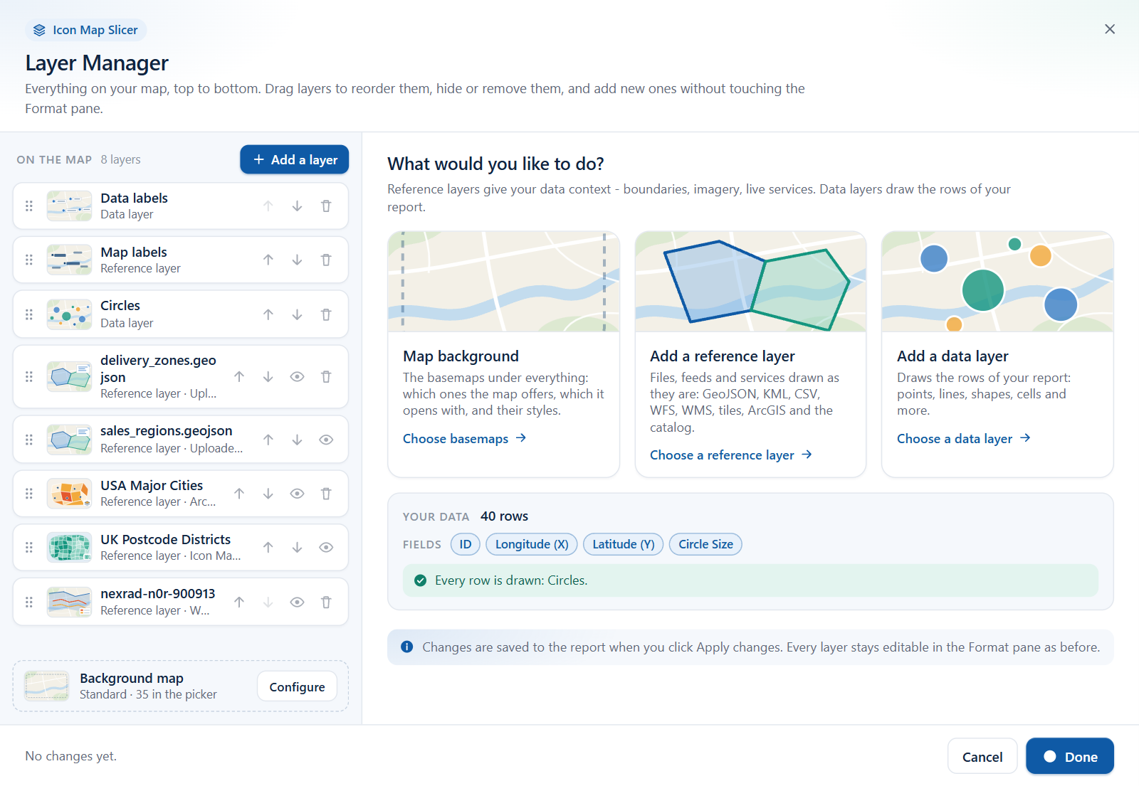
Layer Manager
- See every layer on the map in one list, in the order it is drawn.
- Add data layers and reference layers step by step, with a check of each link before it is added.
- Change the most used style options, drag layers into a new order, hide them or remove them.
- Your data shows how many rows each layer draws. When a layer draws nothing, it shows you example rows, explains why they are skipped and suggests a fix.
- Picking a layer in the "What kind of map are you making?" guide opens the Layer Manager on that layer.
See Layer Manager, Add a layer and Check your data.
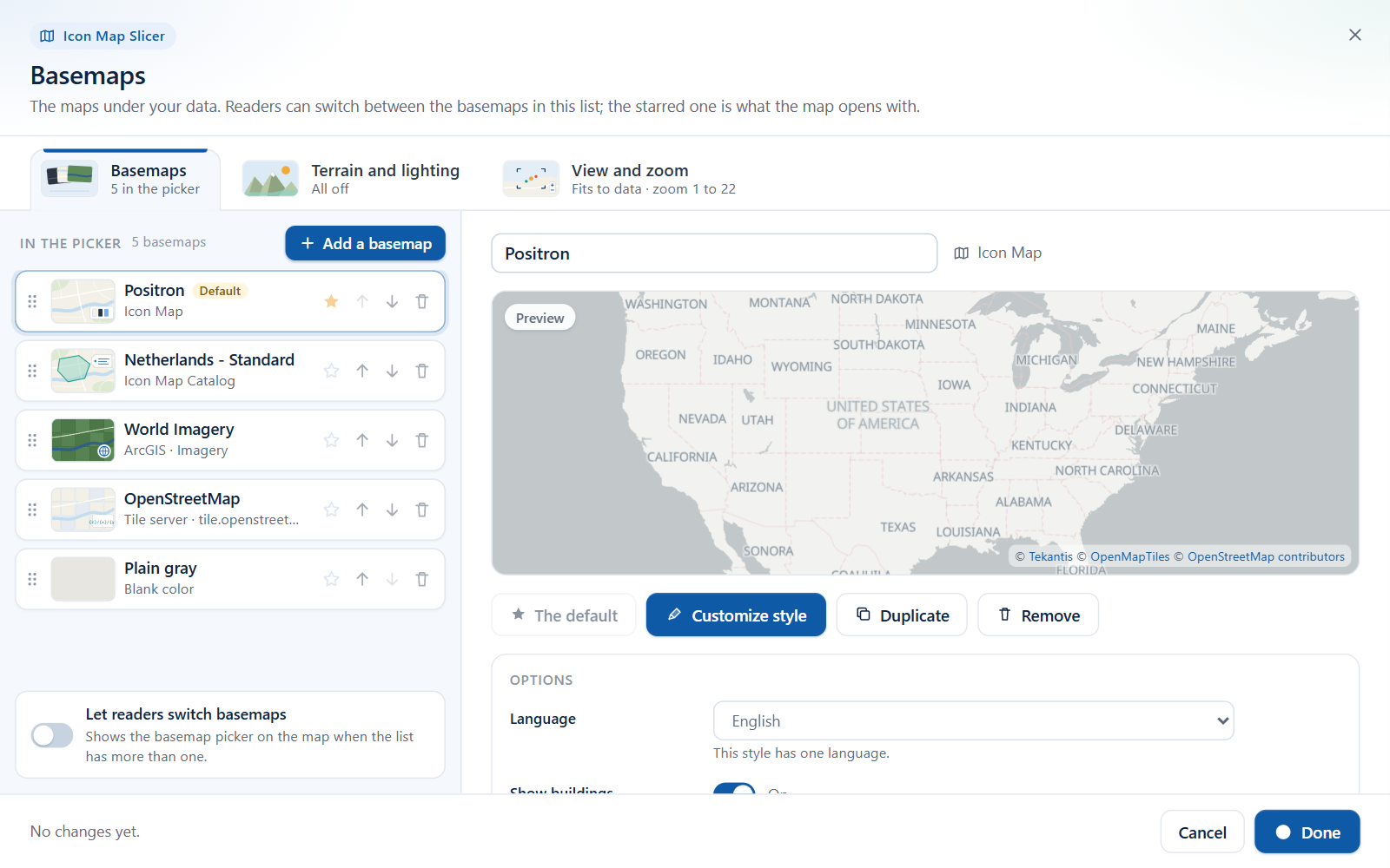
Basemaps dialog
- Give a map a list of basemaps and choose the one it opens with. The list can mix Icon Map styles, basemaps from the Icon Map Catalog, ArcGIS basemaps and web maps, tile servers, MapLibre style links, WMS services and a plain color.
- Let report readers switch between them with a basemap picker on the map: turn on Show basemap selector.
- Customize a basemap style layer by layer in the style editor, with a JSON view for exact edits.
- Set hillshade, 3D terrain, light and sky on the Terrain and lighting tab, and zoom, tilt and projection on the View and zoom tab. Settings new to Icon Map Slicer are only in the dialog: switch Tilt off or raise Steepest tilt up to 180 degrees, Keep readers inside an area, switch Animation off, and zoom to the selection with Zoom to selected items, Zoom back out afterwards and Zoom to the selection when the map redraws. See View, zoom and projection.
The dialog is used by maps added to a report in 1.1.0.11 or later. Older maps keep the Background Layer card, which now offers ArcGIS as a second basemap source next to Icon Map. See The Basemaps dialog, Customize a basemap style and Basemaps overview.
ArcGIS
ArcGIS is new to Icon Map Slicer.
- Reference layers: up to five ArcGIS layers, from feature, map, imagery, tile and vector tile services and whole web maps. Layers can use their ArcGIS symbology, labels and pop-ups, open a pop-up on click, and reload on a timer.
- A data layer: Data Layers > ArcGIS Layer joins your rows to the features of an ArcGIS feature layer and styles them with your values.
- Basemaps and elevation: ArcGIS basemaps and web maps, and ArcGIS elevation for hillshade and 3D terrain.
- Finding and connecting: Browse ArcGIS searches for content with a preview, and Sign in with ArcGIS connects with your own ArcGIS account. The ArcGIS Authentication card appears in the Format pane once the map uses ArcGIS, with Test Connection and Send Credential As.
See ArcGIS layers, Connect to ArcGIS and ArcGIS layers bound to data.
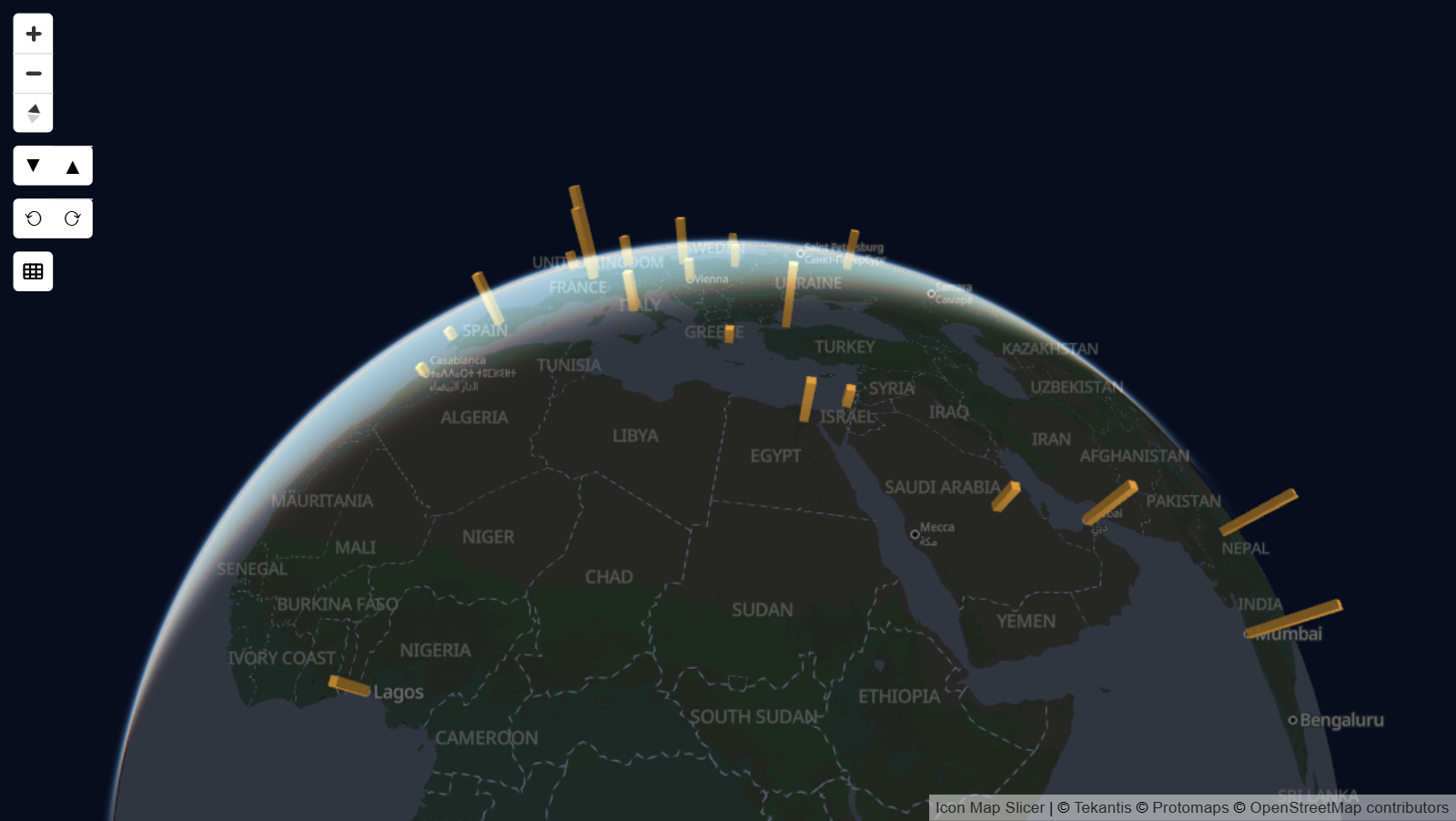
The map
- A globe projection, with an optional Globe Toggle button on the map that switches between the globe and the flat map. The choice is saved with the report.
- Sky settings, and Light settings that now take effect.
- Better 3D terrain, smoother edges, and labels in right-to-left scripts drawn correctly.
See View, zoom and projection and Terrain, hillshade, sky and lighting.
Getting started
- A new start page with example maps, links to every layer and way of filtering, and a sample report.
- The "What kind of map are you making?" guide appears when your rows do not reach a layer. It shows which fields each layer type needs and turns a layer on when you pick it. See Choose a layer type.
- Blank text cells now count as empty, so tables from CSV files, Excel and Power Query can feed several layers without extra measures. See Combine several layers in one map.
New ways to draw data
- New line shapes: Flow Arcs, Flow Tree and Routes, and 3D Arcs drawn on the globe with an amplitude you can set per row. Dash patterns can differ on each row and animate. See Lines and Routes.
- More cell grids: Geohash alongside H3, S2 and A5, and custom shapes that count points inside polygons you upload. See Cells: H3 hexagons and grids.
- PMTiles uploads: PMTiles archives as shapes from files and as reference layers.
- Label styles: Glass, Dark Glass, Card, Neon and Halo Text, with titles, images and footers, and labels that appear on mouse over or when selected. Reference layer labels can be formatted per layer. See Data labels.
Reference layers
- File layers added by link in the Layer Manager now read GeoJSON, TopoJSON, KML, KMZ, CSV files with coordinates, and WFS services, and can reload on a timer.
- Raster layers added in the Layer Manager accept a WMTS service link as well as a tile template.
- Raster layers added in the Layer Manager also accept a raster PMTiles link.
- Reference layers from files appear in the legend and in the layer control, under their title, file name or "Reference layer n". ArcGIS layers appear with their own ArcGIS legends.
- When a server does not allow Power BI to read a link, the layer can be read through the Icon Map proxy, and Use proxy when required in the layer's editor changes that later. Each server is tried directly first, and the proxy is never used when Airgapped Environment is on or the license rules it out.
See Files and feeds, Raster tiles, WMTS and WMS and ArcGIS sign-in and the proxy.
Selection and filtering
- Selecting is faster, and no longer reloads the map's tiles.
- Travel time selection uses a calibrated travel model, and Area Outline chooses between an outline that follows the roads and a single outline.
- The lasso, circle select and travel time leave out items whose Selectable setting is No, and an area that holds exactly the current selection no longer clears it.
- Selecting a selected cell or shape again clears the selection.
- Ctrl+click on the last selected item clears the filter.
- Map Location works with longitude and latitude fields summarized as Average.
- Selecting or clearing items keeps the map view filter, and the map view filter works across the 180 degree meridian.
See How Icon Map Slicer filters, Select by travel time and Filter by the map view.
Languages
Icon Map Slicer is available in German, Spanish, French and Portuguese as well as English. The visual follows the language of the Power BI report: the Build and Format panes, the map controls, the legend, dialogs and messages. See Languages.
Basemap place names follow the report's language too, on Icon Map styles that have several languages. The Language settings start on Report language. Choose a language, English included, to keep that one. See Icon Map basemap styles.
Fixes
- The lasso and circle select include the item in the first row of your data, and a lasso that ends where it started no longer clears the selection.
- Shapes (from files) drill-down draws the files from links at every level.
Changes to be aware of
- The map needs WebGL 2. Without it, the visual shows a message instead of a map. See Supported environments and limits.
- Lines that do not have both an origin and a destination are no longer drawn.
- In a report in German, Spanish, French or Portuguese, an Icon Map basemap or Map Labels layer whose Language was never set shows place names in the report's language. To keep English names, set Language to English.
- The Layer Manager card is now the first card in the Format pane. It replaces the Diagnostics card: the data summary is now Your data in the Layer Manager.
- The visual asks for one more Power BI privilege, local storage. It is optional, and used only to remember an ArcGIS sign-in.
- Most names in the Reference Layers and Data Layers cards of the Format pane have not changed. The new file, WFS, WMTS and proxy options are in the Layer Manager.
- A few names did change: Show Layer Selector is now Show basemap selector, the legend's Overlay 1 to Overlay 5 are now Reference layer 1 to Reference layer 5, and in Shapes (from files) the link is File or Service Link and the outline group is Shapes (from files) - Outline Formatting.
- The Images layer's Z Index (Format pane > Data Layers > Images - Configuration) takes effect. Images are drawn at their own place in the drawing order, 410 by default, so they now draw above Lines (409) as well as Circles (405).
- License keys for air-gapped networks now work, and the visual no longer stays blank on a Power BI Report Server that uses HTTP. See Power BI Report Server (on-premises).
Earlier versions
Version 1.1.0.9 and earlier are covered by the documentation for 1.1.0.9 and earlier. The Release notes list every version.