
Basemaps overview
The basemap is the map drawn underneath your data: streets, satellite imagery, a quiet gray canvas or a plain color. This section covers choosing a basemap, and everything about the view on top of it - zoom, tilt, the globe, terrain and lighting.
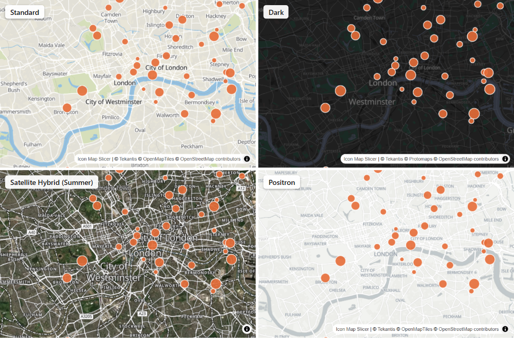
What a basemap does
A basemap gives your data its geographic context. It sits at the bottom of the map, below every data layer and reference layer. Selecting items on the map, or filtering the report, never changes it.
Icon Map Slicer includes its own basemap styles, hosted by Tekantis. They need no account or key, and a map that has never had its basemap changed uses the Standard style.
From 1.1.0.11 you can also use ArcGIS basemaps. New maps can add the Icon Map Catalog, your own tile server, a MapLibre style that you host, a WMS service or a plain color as well.
Where the basemap settings are
There are two places to set the basemap. Which one your map uses depends on how the map started:
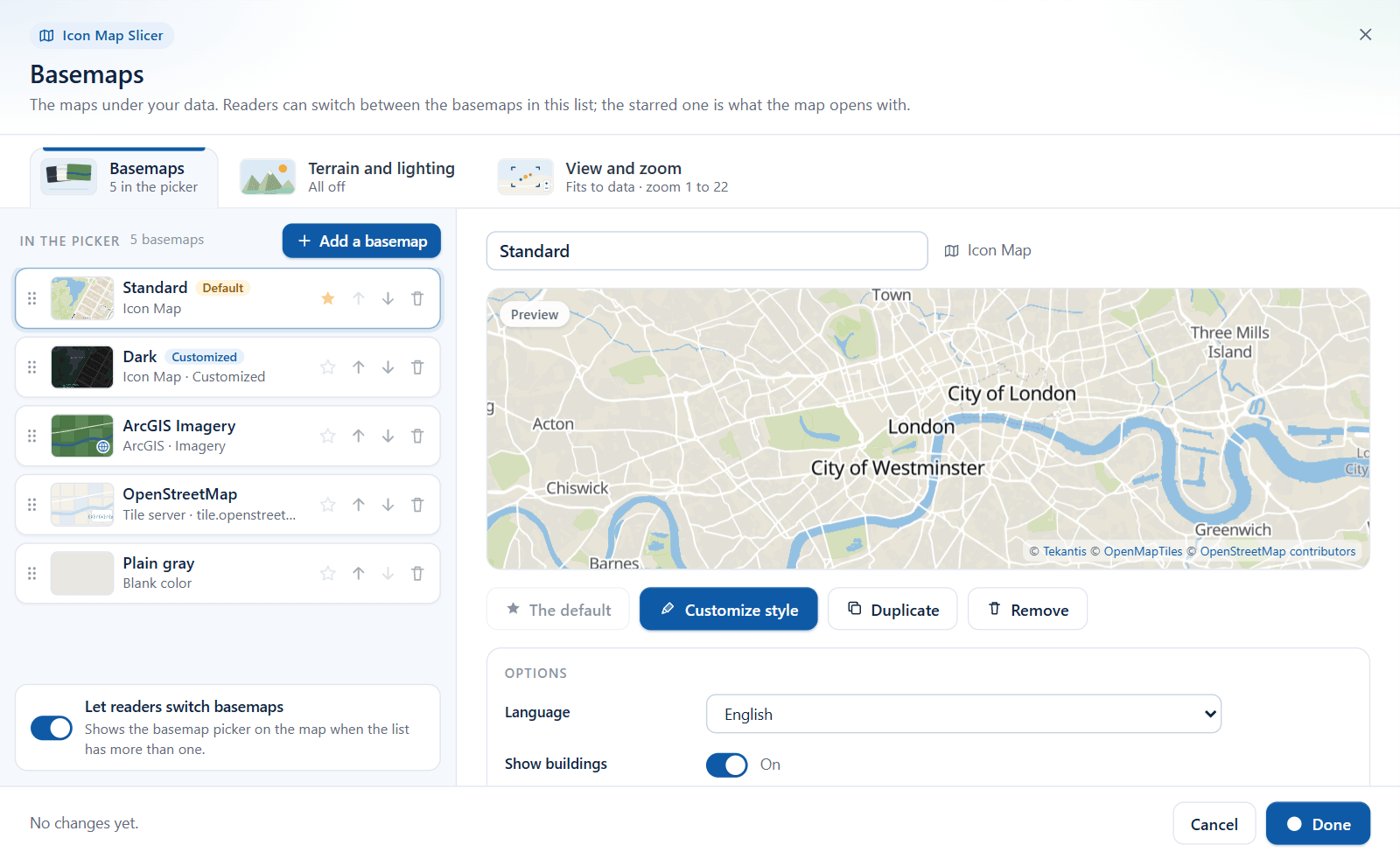
- New maps use the Basemaps dialog. A new map is one that was added to a report as an empty visual in Icon Map Slicer 1.1.0.11 or later. It has a basemap list: one or more basemaps, one of them the default, which readers can switch between on the map.
- Earlier maps keep the Background Layer card in the Format pane. These are maps added in 1.1.0.9 or earlier, and reports built in Icon Map Lite and switched to Icon Map Slicer. They have one basemap, chosen in the Format pane, as before. The card can now also draw an ArcGIS basemap.
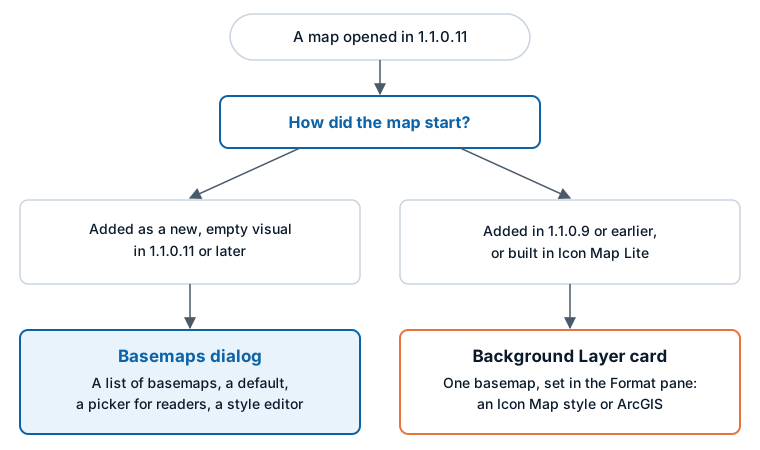
To check which one your map has, open Format pane > Background Layer:
- If the card shows a single Basemaps group with a Configure Basemaps switch, your map uses the Basemaps dialog. See The Basemaps dialog.
- If the card starts with a Map Source group and a Background map source dropdown, your map uses the Format pane. See Set the basemap in the Format pane.
The rule exists so that nothing changes in a report you have already built. An earlier map draws exactly as it did before you updated.
Where basemaps come from
| Source | What you get | What you need | Where you set it |
|---|---|---|---|
| Icon Map | The built-in styles: street maps, light and dark canvases, satellite imagery and more | Nothing. Included with Icon Map Slicer | The Basemaps dialog or the Format pane |
| ArcGIS | Esri basemap styles, OpenStreetMap styles by Esri, your own vector styles, tiled services and web maps | An ArcGIS API key or another ArcGIS connection for Esri's basemap styles. Public services need none | The Basemaps dialog or the Format pane |
| Icon Map Catalog | Ready-made national and regional basemaps: aerial imagery, topographic and street maps | Nothing for Basic basemaps | The Basemaps dialog |
| Tile server | Any XYZ tile server | The tile template link | The Basemaps dialog |
| MapLibre style | A style document that you host | The style link | The Basemaps dialog |
| WMS | A layer from a WMS service | The service address | The Basemaps dialog |
| Blank | A plain color instead of a map | Nothing | The Basemaps dialog |
On a map that uses the Format pane, you can still draw a style document that you host: choose Custom Style URL in the Icon Map style list. See Icon Map basemap styles.
The Icon Map styles are described in Icon Map basemap styles. Every other source is described in Other basemap providers.
Icon Map Pro also offers Azure Maps, Mappable and Ordnance Survey basemaps with your own key. Icon Map Slicer does not.
The view, terrain and lighting
Some settings belong to the map as a whole and not to one basemap. They stay as they are when the basemap changes:
- How the map zooms to your data, how far readers can zoom and tilt, and whether the map is flat or a globe. See View, zoom and projection.
- Hillshade, 3D terrain, the light on 3D objects, and the sky. See Terrain, hillshade, sky and lighting.