

It's day 23 of the 30 Day Map Challenge, and today's theme is one of the senses: taste. "Food, drink or something else which you can taste."
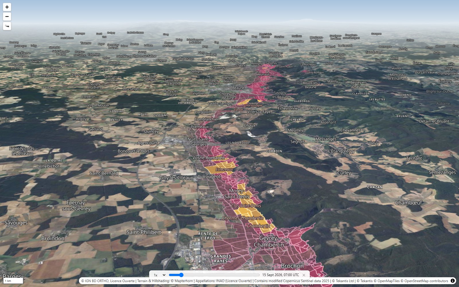
So here is a slope you can taste. Burgundy's Côte d'Or is a single hillside, 44 km long, running south from near Dijon to Santenay. It faces east, into the morning sun. The same two grapes grow almost everywhere on it: Pinot Noir for the reds and Chardonnay for the whites. And yet French law ranks every vineyard on it, field by field, and a wine from one side of a farm track can be worth many times a wine from the other.
There are four ranks. The regional wines can come from almost anywhere in Burgundy. The village wines come from one named village. The Premier Crus come from one named vineyard, a "climat", inside a village. And the Grand Crus are the very best climats, so famous that they're appellations in their own right: Chambertin, Romanée-Conti, Montrachet. The map tints each one over aerial photographs, so you can still see the rows of vines: regional in faint plum, village in wine red, Premier Cru in pink and Grand Cru in gold.
The gold is very small. The Côte d'Or has 32 Grand Crus, and between them they cover 473 hectares, less than 5 km². The Premier Crus add 448 more climats and about 2,000 hectares. Hover over any area to see its name, how high it sits, how steep it is and which way it faces. Use the bookmarks along the top to move around, and press play on the time slider to move the sun across a harvest day: 15 September.
Where the gold is
The Grand Crus aren't scattered at random. They sit in a band part way up the slope. Most of their ground is between 250 and 305 m above sea level, a band about 55 m tall. The village land is spread over almost twice that height, running down toward the flat plain of the Saône and up toward the woods at the top. Burgundians have long said the best wine comes from the middle of the slope, where the soil is deep enough but drains well, and that's exactly where the law put the gold.
They also face the right way. 82% of the Grand Cru ground faces somewhere between east and south, toward the morning sun.
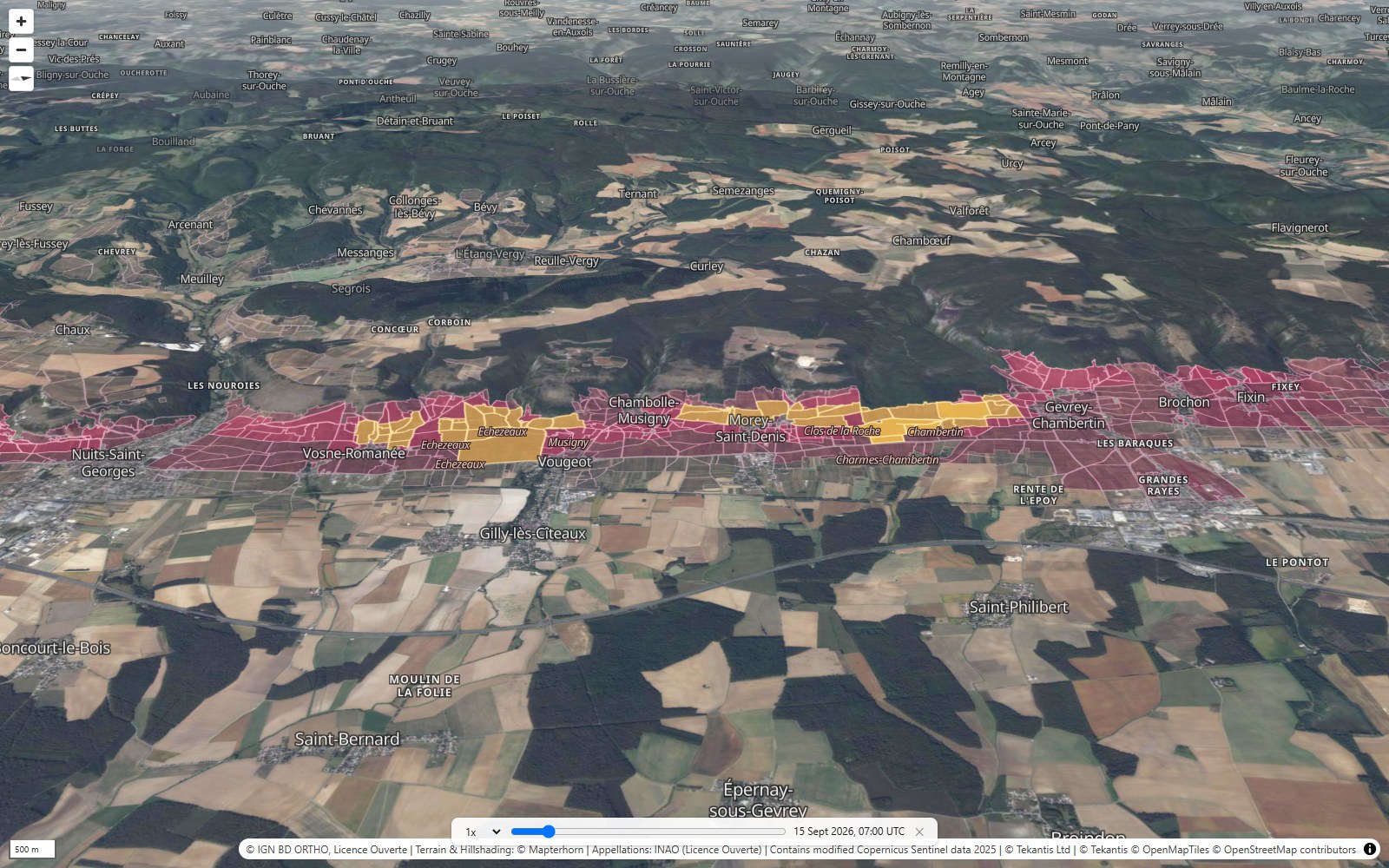
The second bookmark shows the Côte de Nuits, the northern half, where nearly all the red Grand Crus are. From Gevrey-Chambertin to Vosne-Romanée they almost join up into one gold line along the slope, facing east.
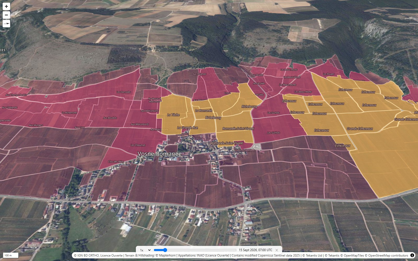
Then zoom right in on Vosne-Romanée. Romanée-Conti, perhaps the most famous vineyard in the world, is 1.81 hectares: about two and a half football pitches. Its neighbor La Romanée is smaller still, at 0.84 hectares. Around them are La Tâche, Richebourg and Romanée-Saint-Vivant, and then the Premier Crus. Just downhill, Clos de Vougeot is the biggest Grand Cru of the Côte de Nuits, at 51 hectares, and the lowest and flattest: it runs from mid-slope right down to the main road.
The hill of Corton
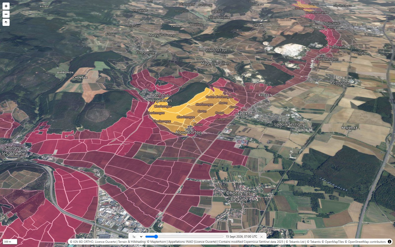
Corton breaks the pattern. It's a round hill standing out from the slope, and its Grand Crus wrap around it like a collar: Corton on the south side, mostly red, and Corton-Charlemagne turning round to the south-west, mostly white. At 160 hectares, Corton is the biggest Grand Cru in Burgundy. Move the time slider to the afternoon and watch the light come round onto its western side.
Montrachet
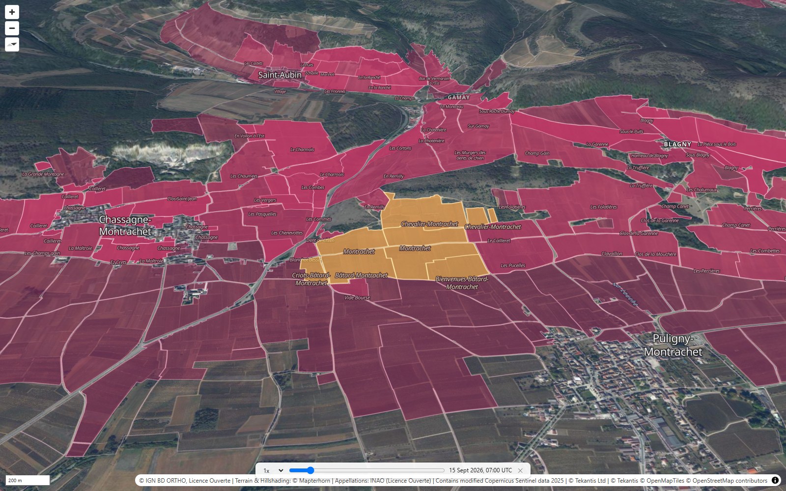
The last bookmark goes to the great white wines, at the southern end. Montrachet is 8 hectares, split between the villages of Puligny and Chassagne, and it faces south-east. Chevalier-Montrachet sits just above it, on steeper ground, and Bâtard-Montrachet just below. Three fields, one above the other, three different wines.
How did I build it?
I built this one using Icon Map's MCP service. The boundaries come from INAO, the French body that runs the appellation system. It publishes the delimited area of every wine appellation as open data, drawn from the land registry, field by field. I took the 1,243 areas in the Côte d'Or département, sorted them into the four ranks, and named each Premier Cru by its climat.
To check the story, I measured the slope under each area from the same elevation data the map uses for its 3D terrain: its height, how steep it is and which way it faces.
The result is a table of 603 areas stored as a file in a Fabric lakehouse. In Icon Map for Fabric each rank is its own geometry layer, drawn straight onto the 3D terrain, with the Grand Crus on top. Underneath are IGN's own 20 cm aerial photographs, streamed straight from IGN's tile service, so close in you can see the vines themselves. The height is exaggerated two times, because the real slope is gentle: about 5 degrees on average. The terrain is shaded by the sun, and the sun follows the time slider.
How accurate is it?
INAO publishes these boundaries for information. The official versions are the plans held in each town hall, and a few appellations haven't been digitised yet.
The areas are where a wine may be made, not where vines are actually planted. Some of the land inside them is roads, houses or woods.
The ranks are legal categories. They don't measure taste or price, though they predict price very well.
Some Grand Crus overlap. Charmes-Chambertin and Mazoyères-Chambertin share the same ground, and Charlemagne lies inside Corton-Charlemagne, so I've counted each hectare only once.
The aerial photographs are streamed live from IGN and were flown on IGN's own schedule, so they may not show the vineyards in the same year as the boundaries.
The heights and slopes come from elevation data with cells about 13 m across, so a tiny climat is only a handful of cells. The regional Bourgogne appellation goes far beyond the Côte, so I've cut it off 2 km from the rest.
Sources
Appellations: INAO, Délimitation parcellaire des AOC viticoles, 9 November 2026, published on data.gouv.fr under the Licence Ouverte.
Aerial imagery: IGN BD ORTHO (Licence Ouverte), from the Géoplateforme.
Terrain: © Mapterhorn.
Commune names: geo.api.gouv.fr.
Basemap: © Protomaps © OpenStreetMap contributors.